Green Infrastructure Implementation Funding - Private Sector Costs Proposed as Offsets Paid by Benefiting Municipalities

How to fund green infrastructure and low impact
development stormwater management measures on
private property .... no easy answers. 
The report Economic Instruments to Facilitate Stormwater Management on Private Property is an interesting read, looking at how green infrastructure (GI) could be implemented and funded on private property to advance stormwater management goals. There is a link to the report.

The White Paper / study report explores the costs and benefits of green infrastructure, or low impact development (LID) measures, and looks at the barriers to implementation on private property - and there are many. These Barriers to the Implementation of LID Technologies include:

1. High up-front costs
2. Uncertain ongoing maintenance requriements
3. Low return on investment
4. Limited benefits accrue directly to property owners, yet they incur the high costs
5. High transaction costs

The report illustrates the types of costs and benefits under #4 in the following graphic:

Imbalance in public and private costs and benefits for green infrastructure / low impact development implementation.
The graphic illustrates that private costs are high, but the majority potential benefits are public.  Also, the private benefits are very low, like the potential reduction in stormwater management fees available to compensate for the GI or LID measures.

How high are the costs for implementing GI or LIDsfor improved stormwater management? Another interesting graphic shows annualized costs considering capital costs distributed over a 25 year service life (e.g., like annual depreciation of the asset) and annual operation and maintenance (O&M) cost.

LID capital and operation and maintenance costs greatly exceed the potential annual credit for stormwater fees. 
The report's impervious percentage of 20% seems too low
compared to typical urban development patterns in Ontario.
Typical residential percentages are double the report's
assumed value. Typical non-residential percentages can
even be higher (i.e., lots covered almost entirely by impermeable
roof top and parking lot surfaces.
The annual cost of LID measures averages about $5,000 per year considering a 'lot size' drainage area of 5000 square metres, or $10,000 per hectare. The cost estimates consider an area with 1000 square metres of impermeable area, meaning an impervious area percentage of 20% (i.e., very, very low for many urban areas ... meaning these average costs should be higher - see example impervious area coverage at right - while this is residential development, non-residential development has followed similar trends).

Given the disparity in costs and benefits, an obvious barrier to implementation of GI and LID on private property, what is proposed to incentivize implementation? Make someone else pay of course! Who pays? The Public Sector. They call this "OFFSETS" and explain it as follows:

"Offsets are payments offered to proponents of LID infrastructure in compensation
for costs incurred when significant benefits accrue to other parties. A principle of
equity or fairness underlies this type of compensation based on the argument that
costs should be borne proportionately by those who benefit from the green
investment.

Public sector contributions in the form of offsets are justified to achieve a balanced
approach to cost sharing that reflects how all costs and benefits are incurred. Doing
this requires identification and quantification of benefits.."

So ultimately, the idea is that the public pays regardless of whether GI or LID is implemented on public land or on private land. What could these costs be in Ontario and what are the impacts to Ontario taxpayers?
Ontario has over 850,000 hectares of urban land use that
does not have enhanced stormwater management control, and
could be eligible for green infrastructure (LID) retrofits.

Ontario's SOLRIS land use mapping indicates 852,000 hectares of urban land use as of the year 2000. Previously we've estimated the capital cost considering a unit cost of $390,000 per hectare based on Ontario tender costs - see image ar right. All this urban land would in all likelihood have no water quality treatment and be eligible for stormwater managment enhancements. How do we know? Table 1 in the Economic Instruments to Facilitate Stormwater Management on Private Property report indicates that despite the use of quality controls, "Use of enhanced controls is negligible." (see table below).

If we retrofit the untreated area with GI / LID, the annualized cost would be simply $10,000 per hectare x 852,000 hectares = $8.5 billion per year ... forever.

Assuming this cost is allocated to municipalities who benefit from the green infrastructure, and these municipalities distribute the cost to Ontario households, we can estimate the annual household cost. The 2016 census indicates that there are 5,169,170 private households in Ontario meaning a cost of $1650 per household per year. Given household after-tax income of $65,285, the green infrastructure cost would represent about 2.5% of this income.

The Ontario stormwater infrastructure deficit has been estimated at $6.8 billion. If green infrastructure / low impact development lifecycle costs are not funded annually by taxpayers, and debt is used to fund the infrastructure investment, like a green bond, this deficit would double in a single year, and increase by the more than the existing deficit each and every year.

Allocating GI / LID costs seems like a shell game.
Allocating GI / LID costs seems like a shell game, shifting private property costs to the public sector, shifting public sector costs to
the downstream municipalities that accrue potential benefits. In the end there is only one source of funding however.... all of us. Elaborate credit systems, offset schemes, Drainage Act assessments, and fancy 'green bonds' are ways of spreading out the high up-front cost of LIDs. But ultimately, we all pay.

It will be interesting to see the next stages of the study authors' work and how the White Paper could be applied. The report states for example "The White Paper also provides background for a pilot study to be undertaken in the Southdown area of Mississauga. This study will examine the potential of aggregating private commercial property under the Drainage Act to secure installation of communal LID technologies and realize cost-efficiencies." The exploration of the Drainage Act was part of another study under the banner "Aggregated Communal Approaches to Green Infrastructure Implementation". The Drainage Act allows costs to be distributed to landowners across catchments in which improvements are made - the challenge is that landowners against whom costs are assessed have to buy in to the cost-sharing plan and can appeal.


Evidence-based policy gaps in water resources - Thinking Fast and Slow on Floods and Flow

Twitter.
Wanted: Evidence-Based, Data-Driven Water Resources
Engineering Policy .. Braaaaaaaaains !

Fake News.

Click Bait.

Infographics.

Infotainment.

One might expect that the "dumbing-down" of media and our communications surrounding topics of great importance to society would not affect the engineering profession, and the important things that we do to serve the public and protect the environment. But you'd be wrong.

I first explored the how discussions and reporting on extreme weather and flooding in water resources engineering have fallen prey to the knee-jerk-reaction, quick-fix crowd back in late 2015 in this post called "Thinking Fast and Slow About Extreme Weather and Climate Change":


My first inclination that facts were falling by the wayside came earlier in 2015 when I found that the Insurance Bureau of Canada and Institute for Catastrophic Loss Reduction's Telling the Weather Story cited arbitrary weather frequency shifts as real Environment and Climate Change Canada IDF data - that was laid out in this presentation.

Now my examination of how we frame and solve problems in the realm of flood risk management - including the identification and prioritization of causes of flooding - has been published in the Journal of Water Management Modeling. Its called Evidence Based Policy Gaps in Water Resources: Thinking Fast and Slow on Floods and Flow :


What's it all about? Well here's the paper's abstract:

"Water resources management and municipal engineering practices have matured in Canada over recent decades. Each year, more refined analytical tools are developed and used in urban flood management. We are now at a state where practitioners must use these tools within broad decision making frameworks to address system risks and the life cycle economics of prescribed solutions. Otherwise, evidence based policy gaps in the prioritization of risk factors and damages will widen and lead to misdirected mitigation efforts. For example, despite statistically significant decreases in regional short duration rainfall intensities in Southern Ontario, extensive resources are devoted to projecting IDF curves under climate change. Thinking fast, as defined by Daniel Kahneman, through listing recent extreme events to declare new weather reality risks based on heuristic availability biases, has replaced data driven policy and the statistical rigour of thinking slow problem solving. Under this skewed risk perspective, a high profile Ontario commuter train flood was mischaracterized as an unprecedented event despite a <5 y return period and a greater flood weeks before. Recent Ontario urban flood incidents have been attributed to unprecedented weather despite GIS analysis showing more critical hydrologic drivers. Constraints on effective water management are now less likely to be technical but rather scientific (inadequate representation of urban groundwater systems), institutional (arbitrary boundaries between city and watershed agency jurisdictions), economic (unaffordable green infrastructure solutions based on cost–benefit analysis and flat normalized loss trends), or operational. Evidence based policies and water management solutions are needed from a broad risk and economic framework that recognizes these barriers and uncertainties in the application of analytic tools."

If you've read the www.cityfloodmap.com blog you've seen these themes before. But nonetheless please give it a read and pass on your comments! Thanks so much.

Robert J. Muir, M.A.Sc., P.Eng.
Toronto

Extreme Rainfall and Climate Change in Canada and Ontario - Compiled Engineering Reports, Research Papers and Presentations by Esteemed Hydrologists Indicate No Change

We have sent a request to the Globe and Mail regarding a recent article on climate change and extreme rainfall and flooding. Specifically we have requested that a correction be made to this statement:

"Moreover, extreme weather related to climate change appears to be increasing the frequency and severity of flooding events."

The article was entitled "How we can better mitigate flood risk in Canada", January 15, 2018, by Glen Hodgson, a senior fellow at the Conference Board of Canada. This is a link to the article .. or should we say the "Opinion Piece":


Certainly everyone is entitled to their own 'opinion', but not their own 'data'. With that in mind we have asked the Globe for a correction based on the following data and analysis (we have added to the original list of reports since making the request):

***

The following engineering reports, thesis documents, peer-reviewed papers, presentations by Canada's most esteemed hydrologists and comments by Environment and Climate Change Canada staff clearly refute the Globe article statement that the frequency and severity of extreme weather is increasing and that "extreme weather related to climate change appears to be increasing":

i. City of Guelph – Ward 1, Frequency Analysis of Maximum Rainfall and IDF Design Curve Update, Earthtech, 2007. Concludes that city would “prefer to retain the existing curves and higher values” as updated rainfall intensities were lower.


ii. Updates of Intensity-Duration-Frequency (IDF) Curves for the City of Waterloo and the City of Kitchener, University of Waterloo, 2012: indicates “new IDF curves tend to be lower .. for rainfall durations up to one to two hours”.


iii. Rainfall Intensity-Duration-Frequency (IDF) Curves RFP11-080 Engineering Design Criteria and Standards Update (DRAFT), fabian papa & partners inc., 2012. Found that “City’s existing criteria ... are more conservative than recently compiled statistics” and “up-to-date Environment Canada IDF Curves will result in lower storm intensities”.


iv. Trends in Canadian Short‐Duration Extreme Rainfall: Including an Intensity–Duration–Frequency Perspective, Environment Canada, Atmosphere Ocean 2014: indicates “lack of a detectable trend signal” across Canada an no regional increases in Ontario.


v. Precipitation Intensities for Design of Buried Municipal Infrastructure, Yi Wang, University of Guelph, Ph.D Thesis 2014: identifies 24 significant increases and 41 significant decreases.


vi. Waterloo Sanitary Master Plan, Volume 1, Appendix A Climate Change, Stantec, 2015. The study did not identify any rainfall intensity changes but adopted a different rainfall pattern to be more conservative in design.


vii. Changes in Rainfall Extremes in Ontario, International Journal of Environmental Research, University of Guelph, 2015. The paper that identified “results of this study indicate that the +ve and -ve changes in annual rainfall extremes are similar in the order of magnitude.”


viii. Short Duration Frequent Rainfall Show No Change in Southern Ontario IDF Design Intensities - No Change in Averages Suggests No Change in Extremes, Muir, 2018. This analysis of Environment and Climate Change Canada’s IDF statistics from 1990 to the current Version 2.3 Engineering Climate Datasets shows no change in 2-year to 10 year 5-minute to 2-hour rainfall.

http://www.cityfloodmap.com/2018/01/short-duration-frequent-rainfall-show.html

ix Floods in Southern Ontario Have Changed, University of Guelph, MNRF Floodplain Technical Workshop, Vaughan, March 7, 2018. Professor Emeritus Dr Trevor Dickinson presented  last week that:

"In fact:
- the number of rainfall events has not increased,
- the total amount of rainfall occurring over the growing season has not increased, &
- to date, there is no evidence that rain storms are more severe."


x Environment and Climate Change Canada (ECCC) has commented to the CBC/Ombudsman to dispute insurance industry statements that we have more storms (see letter to me at this link):


That was in response to this story that had no fact-checking on extreme weather frequency:


And which had this correction made based on ECCC and real data: "However, Environment Canada says it has recently looked at the trends in heavy rainfall events and there were "no significant changes" in the Windsor region between 1953 and 2012." 

xi Canadian Underwriter editors dispute insurance industry statement on more frequent / severe storms after fact-checking with ECCC: 


"Associate Editor’s Note: In the 2012 report Telling the Weather Story, commissioned to the Institute for Catastrophic Loss Reduction by the Insurance Bureau of Canada, Professor Gordon McBean writes: “Weather events that used to happen once every 40 years are now happening once every six years in some regions in the country.” A footnote cites “Environment Canada: Intensity-Duration-Frequency Tables and Graphs.” However, a spokesperson for Environment and Climate Change Canada told Canadian Underwriter that ECCC’s studies “have not shown evidence to support” this statement."

Please issue a correction to the article. Thank you.

Robert J. Muir, M.A.Sc., P.Eng. 
Toronto

***
BONUS - the City of Ottawa has also reviewed IDF curves in October 2015 and found the following:

https://drive.google.com/open?id=1ar9JgTSag0JtbBJTyTHVCvEpFnLXopkn

"The IDF curves used for sizing of storm sewers and stormwater management designs that are currently in use at the City and provided in the Ottawa Sewer Guidelines (OSG) is based on rainfall data collected at the Ottawa McDonald Airport from 1967 to 1997 by Environment Canada (further referred to OSG IDF Curves).  Environment Canada updated the IDF curves using data to 2007 (further referred to as 2007 IDF Curves).  Over the recent past years, the update was brought to ISD’s attention for adopting into the OSG.

 A comparison of the OSG and the 2007 IDF curves revealed that for short durations the intensities from the 2007 IDF Curves are less than the OSG IDF Curves on average by 5% and 10% for the 5 year and 100 year curves respectively.  However, for the longer durations the intensities for the 2007 IDF Curves are actually greater than the OSG IDF Curves on average by 11% and 17% for the 5 year and 100 year curves respectively.  The intensities at the shorter durations would influence storm sewer sizing while the longer durations will influence stormwater pond sizing.  The lower intensities at the short durations will tend to result in smaller storm sewer sizes while the larger intensities at higher durations will tend to increase stormwater management pond requirements.  

Commentary:

Given that the percentage differences in intensities between the IDF curves is within the margin of error associated with data collection and hydrologic assessments, it was ISD’s opinion not to update the OSD IDF curves.  As part of the Stormwater Levels of Service review, the need to revisit the IDF curve selection was identified."

Because stormwater ponds are not designed with IDF curve statistics alone, i.e,. they are designed by simulating temporal patters of storms in hydrologic/hydraulic models, it is questionable if an IDF shift in long durations alone would alter the design of a stormwater management pond. That is the design storm (or hyetograph) pattern would influence the pond performance more than the input IDF used to adjust storm volume. Also, some municipalities assess pond performance assuming the outlet is completely blocked, as an operational worst case scenario, such that all collected runoff is routed through the emergency spillway. In this extreme operating condition, a small change in rainfall volume may not affect overall performance (i.e., spillways operate efficiently as weirs, able to accommodate additional flow release with limited increase in operating level (pond water surface elevation).

ANOTHER BONUS - the City of Hamilton has also reviewed IDF curves in 2015 and found no change that warranted updates in their current standards (R.Muir personal communication with Hamilton engineering staff May, 2018).

YET ANOTHER BONUS - the City of Markham has also reviewed IDF curves in 2018 based on extended rain data analysis considering local data (Buttonville Airport) and data for the long-term Toronto Bloor Street climate station (upon which Markham's standards were based on). This review is summarized in a recent Municipal Class Environmental Assessment Study for Don Mills Channel flood remediation (see report here: https://www.markham.ca/wps/portal/home/about/city-hall/city-projects-initiatives/current/stormwater-management/don-mills-flood-reduction/don-mills-channel-flood-reduction).

The report notes: 

The City of Markham has recently completed a review of past and current climate data and a number of other climate change resources in order to assess the resiliency of the City’s wastewater collection systems. To assess IDF impacts the City of Markham first reviewed national and regional rainfall trends in Environment and Climate Change Canada’s (ECCC’s) Engineering Climate Datasets (version 2.3) and local research and determined that ‘no historical changes in rainfall intensity are expected based on the analysis of national and regional (southern Ontario) datasets’ (Xu and Muir, 2018). This is consistent with extreme rainfall trends analysis by ECCC that indicate ‘a general lack of a detectable trend signal’ nationally (Shephard et.al, 2014).
As part of the assessment, the City of Markham updated local IDF curves for the long-term Toronto City climate station that its design standards are based on, as well as the Toronto International Airport (Pearson) and Markham Buttonville Airport stations IDF curves. The findings related to the wastewater system resiliency assessment, which are also relevant to storm drainage infrastructure, were as follows:
■ “The Pearson station 100-year data showed no change since the ECCC 2013 dataset, and a decrease since the 1990 dataset (average decrease of 3.2%). The Buttonville station 100-year data showed an average increase of only 1.1%. Therefore 100-year short-duration intensities are considered to be stationary for the purpose of the existing system capacity assessment under today’s climate - past rainfall intensities (IDF data) maybe used to assess current wastewater system wet weather performance.”

YET ANOTHER BONUS - the City of Welland has also reviewed its design IDF curves in 2012 in this study. It's consultant found that:

"The following general conclusions stem from the analysis:
• the 1963 IDF curves is conservative relative to the estimates made in the 2000 IDF curves.
Thus, adoption of the 2000 curves would effect a relaxation of planning standards for many
types of infrastructure.
• the 1963 curves were conservative relative to the current (2000) estimates and even relative
to the projected (2020 and 2050) values for many duration/return interval combinations. In
those instances, it is reasonable to retain the 1963 intensities."

So even looking into the future, the city's design rainfall intensities from the 1960's are more conservative. So of course if there has been flooding in Welland it's due to other design considerations (like return period level of service for sewer design, etc.) and not because rain is now, or will be, higher than design intensities.

YET ANOTHER BONUS - the City of Niagara Falls has also reviewed its design IDF curves and found lower rainfall intensities. The following is an excerpt from the MOECC (now MECP) LID Guidance Manual (second draft, page 129):

"Many Ontario municipalities have conducted climate change and/or IDF analysis studies to provide direction for municipal infrastructure planners in light of climate change risks. Of note is the City of Niagara Falls which conducted an IDF curve update and climate change analysis as part of their 2015 Master Drainage Plan Update Study. Updated IDFs for four of the five climate stations within the City were found to generate rainfall volumes and intensities that were slightly lower than those generated by the previous IDF curves (Hatch Mott MacDonald, 2015). Additional analysis conducted for Niagara Falls found that the “average annual rainfall volumes for the past 15 years (2000 to 2014) were actually 5.5% lower than the long term average, and significantly lower (by 12.6%) than the average annual rainfalls in the 1970’s, 80’s and 90’s; and the frequency of the larger rainfall events (> 25 mm) that cause most of the stormwater management and combined sewer overflows problems were all significantly lower than the long term average (by 15-25%)” (Hatch Mott MacDonald, 2015)."


YET ANOTHER BONUS - The Windsor/Essex Region Stormwater Management Standards Manual reviewed City of Windsor Airport IDF trends - see December 2018 report:  https://essexregionconservation.ca/wp-content/uploads/2018/12/WE-Region-SWM-Standards-Manual.pdf


"Table A-3.9.1b showing Windsor Airport extreme rainfall trends from 1995 to 2015 continues to illustrate a decreasing trend for short-duration events from 5min to 30min duration for nearly all return periods. The trends illustrate an increasing trend in 1 hour, 2 hour, 12 hour and to a lesser extent the 24 hour durations."

The review includes data up to 2015 - Table A-3.9.1b is shown below:


YET ANOTHER BONUS - The Ontario Ministry of Transportation (MTO) completed a comprehensive study entitled “The Resilience of Ontario Highway Drainage Infrastructure to Climate Change”  in 2015 that indicates consistently decreasing intensities predicted for short durations affecting urban flooding:

“The IDF predictions in the 2014 UR study (2) also give rainfall predictions with significant variability with location, storm duration and return period (frequency) which can be compared to the 2007 MTO IDF curves. Predicted storms with durations less than 6 hours are less intense than those observed in 2007, for all return periods. Longer duration storms do not always hold to this pattern, with the 6 and 24 hour storms often predicted to become more intense, particularly in Northwestern Ontario.” 

The study noted ranges in predicted increases and decreases for bias-corrected climate models:

“In some areas rainfall intensity increased from 0% to just above 30% where in other areas there were rainfall intensity reductions in the from 2 to 10%.”

The Ontario Ministry of Transportation noted in the report that modern drainage infrastructure including sewers, culverts and bridges are resilient to increases in design flows that may occur due to climate change: 

“An overwhelming percentage of the storms sewer networks tested appeared to have sufficient excess capacity to hand the increases in design flow rates up to 30%. Similarly, the sample of highway culverts analysed showed adequate capacities, for a large percentage of the culvert, to handle the rage of low rate increases investigated without the need to be replaced. The bridges tested also appeared to suffer no risk to structures as a result of the flow increases.”

In response to this low risk, the Ministry’s Highway Standards Branch has developed a policy for assessing risks based on future climate that incorporates flexibility in design. The 2016 memorandum entitled Implementation of the Ministry’s Climate Change Consideration in the Design of Highway Drainage Infrastructure states: 

“Designers are to exercise engineering judgement to determine whether the infrastructure will meet current and future design criteria through appropriate sizing of the infrastructure or through providing allowances for future adaptation measures.”

The Ministry’s approach of allowing for future adaptation as opposed to increasing infrastructure capacity as a result of future criteria (i.e., higher rainfall intensities) is similar to the ASCE approach that advocates the Observational Method that promotes “Design for low regret, adaptability, and robustness, and revisit designs when new information is available.”

***

Wrap-up

A separate post explores IDF trends in the Version 3.0 Engineering Climate Datasets for long term southern Ontario climate stations - previous post link. Here are the results showing an overall decrease of 0.4% in all design intensities, and decreases for all return periods (bottom row) - smaller storms with more observations decreasing the most - and decreasing for most durations (right column) - especially the shorter durations of less than 1 hour:


***

Update: The Globe and Mail responded by 'working their Google' and citing examples of flood damages increasing, diverting from the question on extreme weather frequency. We have explained that flood damages can increase for many reasons and that they have fallen prey to 'attribute substitution'. Check out this recently published paper on heuristic biases and challenges in framing and solving problems related to extreme weather and flooding:
https://www.chijournal.org/C449 

The CBC Ombudsman has recently reviewed data provided on this topic, cited Environment and Climate Change Canada statements and agreed as shown in this post https://www.cityfloodmap.com/2019/01/cbc-ombudsman-decision-finds-lack-of.html

The Minister of Environment and Climate Change Catherine McKenna has also weighed in on this topic indicating that there is no evidence of changes in extreme precipitation (i.e., short duration rainfall affecting flooding).

The letter (at right) was to clarify comments made by Prime Minister Trudeau following Gatineau 2017 flooding that "The frequency of extreme weather events is increasing, and that's related to climate change".

The Minister's letter, drawing from the recent Canada's Changing Climate Report, does not support the Prime Minister's statement on extreme weather frequency.

Construction Era, Infrastructure Standards and Extreme Rainfall Flood Resiliency and Risk

Flooding occurs largely based on clear and quantifiable municipal infrastructure design standards that have evolved over the last century, steadily reducing flood risk. Certainly factors such as urbanization and intensification affect hydrology and increase runoff and risks, even when rainfall intensities have not changed (e.g., southern Ontario for example) - but fundamental design characteristics that may or may not account for extreme weather effects are the predominant factor affecting urban flood risk.

From Flood Plains to Floor Drains, my unifying theory of urban flood risk, described how planning and design practices have evolved within the realms of riverine flooding (i.e., flood plain management), pluvial flooding (i.e., major overland drainage design), and sewer back-ups (i.e., wastewater and stormwater sewer design). These systems may also interact during extreme weather through processes not explicitly considered in the design and that may accentuate core design limitations, or lower levels or service, in the related system. For example, flood plains may back up into sewer systems (e.g., Carp River, Ottawa or Etobicoke Creek, Toronto). Or overland drainage systems may overwhelm sanitary sewer systems with inflows ... insert your local 'Lost River' example here.

So what are the construction eras and infrastructure servicing standards that characterize extreme weather flood resiliency or risk? Here is an approximate grouping that I developed to support a white paper on Core Public Infrastructure knowledge gaps and research needs for the National Research Council last year. That work did not look into riverine systems but those are included here:

Servicing Era 1 - 1960 and before

Median Flood Risk = HIGH (4 out of 5)

Level of Service Profile:
  • Riverine flood risks are not uncommon, unless structural controls have been put in place (e.g., dams, berms, etc) or land use planning has relocated original at-risk dwellings.
  • Pluvial / overland flood risks exist as it was not a common design practice to accommodate major system flows during extreme rainfall events.
  • Sewer back-up risks exist due to high extraneous flow stresses during extreme rainfall events in combined wastewater systems and partially-separated systems (i.e., with foundation drains / weeping tiles connected to the sewer system). Risks may increase if there is reliance on mechanical and electrical systems (e.g., pumping stations in the collection system) or may decrease if hydraulic relief is available through combined sewer overflows (CSOs) or storm sewer overflows (SSOs).
Other Considerations:
  • CSO or SSO hydraulic relief may have a relatively-smaller moderate flood risk (3 out of 5)
  • Systems serviced by pumping systems that have finite capacity or that are affected by flood plain encroachment may have a relatively-higher highest risk (5 out of 5).
Servicing Era 2 - 1960 to 1980

Level of Service Profile:
  • Riverine flood risks vary overall according to natural hazards land use planning (provincial or local policies) and vary locally based on the spatial extent of flood risk mapping (i.e., have large drainage areas (up to about 125 hectares) been mapped or estimated including through urban areas.
  • Pluvial / overland flood risks exist as it was not a common design practice to accommodate major system flows during extreme rainfall events.
  • Sewer back-up risks exist due to high extraneous flow stresses during extreme rainfall events in partially-separated systems (i.e., with foundation drains / weeping tiles connected to the sewer system). Risks may increase if there is reliance on mechanical and electrical systems (e.g., pumping stations in the collection system).
Median Flood Risk = HIGHEST (5 out of 5)

Other Considerations:
  • Systems with good overland catchment slopes may have a relatively-lower high flood risk, despite no explicit overland drainage system (4 out of 5).
  • Systems serviced by pumping systems that have finite capacity or that are affected by flood plain encroachment may have a relatively-higher risk.
Servicing Era 3 - 1981 to 1990

Level of Service Profile:
  • Riverine flood risks may be significantly reduced according to natural hazards land use planning (provincial or local policies) and can vary locally based on the spatial extent of flood risk mapping (i.e., have large drainage areas (up to about 125 hectares) been mapped or estimated including through urban areas.
  • Pluvial / overland flood risks may exist from jurisdiction to jurisdiction as this design practice was introduced to accommodate major system flows during extreme rainfall events, often in combination with master drainage planning at the early land use planning stage.
  • Sewer back-up risks are limited due to low extraneous flow stresses during extreme rainfall events in fully-separated systems (i.e., no foundation drains / weeping tiles connected to the sewer system). Risks may increase if there is reliance on mechanical and electrical systems (e.g., pumping stations in the collection system).
Median Flood Risk = MODERATE (3 out of 5)

Other Considerations:
  • Systems with good overland catchment slopes, often through explicit dual-drainage design for major system design, may have a relatively-lower low flood risk (2 out of 5).
  • Systems serviced by pumping systems that have finite capacity or that are affected by flood plain encroachment may have a relatively-higher highest risk (4 out of 5).
Servicing Era 4 - 1990 to today

Median Flood Risk = LOW (2 out of 5)

Level of Service Profile:
  • Riverine flood risks are typically significantly reduced according to natural hazards land use planning (provincial or local policies) . Local and downstream risks may be reduced through integrated land use and watershed/subwatershed planning.
  • Pluvial / overland flood risks are limited where the dual-drainage design practice was introduced to accommodate major system flows during extreme rainfall events, often in combination with master environmental servicing (including drainage) planning at the early land use planning stage.
  • Sewer back-up risks are limited due to low extraneous flow stresses during extreme rainfall events in fully-separated systems (i.e., no foundation drains / weeping tiles connected to the sewer system). Risks may increase if there is reliance on mechanical and electrical systems (e.g., pumping stations in the collection system).
Median Flood Risk = MODERATE (3 out of 5)

Other Considerations:
  • Systems with no explicit dual-drainage design for major system design may have a relatively-higher high flood risk (4 out of 5).
  • Systems serviced by pumping systems that have finite capacity or that are affected by flood plain encroachment may have a relatively-higher highest risk (4 out of 5).
Servicing Era 4 Plus - Added Enhanced Best Practices to Servicing Era 4

Median Flood Risk = LOWEST (1 out of 5)

OK, so what are the enhanced best practices that create Era 4+ ? Basically take the good practices in Era 4 and add measures that provide enhanced resiliency in each of the realms.

Enhancements:
  • Riverine flood risk reduced through adoption of higher return period events (e.g., above 100-year level of service) or significant freeboard allowances (safety factors in design).
  • Pluvial / overland risk reduced through provision of adequate freeboard on major drainage system to prevent entry to properties.
  • Sewer back-up risks reduced through mandatory plumbing system isolation (backwater valves and sump pumps), or robust hydraulic design of gravity systems to consider extreme rainfall stresses above 100-year level (e.g., including future projected rainfall intensities) and to consider freeboard to basement systems during extreme events, and inlet control devices to limit storm sewer system surcharge.
A longer list of enhanced-level best practices is found in the Intact Centre on Climate Adaptation seed document on Best Practices for New communities:


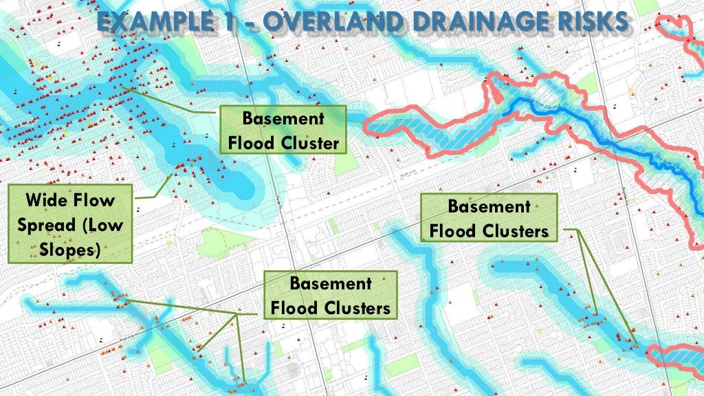
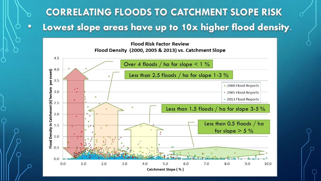
So how do we know these Servicing Eras are relevant and really do affect flood risk? By using data to track reported flooding and correlating the flood density to the servicing era or the characteristic within the servicing era. An example of this is my assessment of overland flow characteristics, and catchment slope characteristics on reported Toronto flood density:


EXAMPLE 1 - OVERLAND DRAINAGE RISKS
Wide Flow
Spread (Low
Slopes)
Basement
Flood Cluster
Basement
Flood Clusters
Basement
...

CORRELATING FLOODS TO CATCHMENT SLOPE RISK
• Lowest slope areas have up to 10x higher flood density.
Over 4 floods / ha fo...

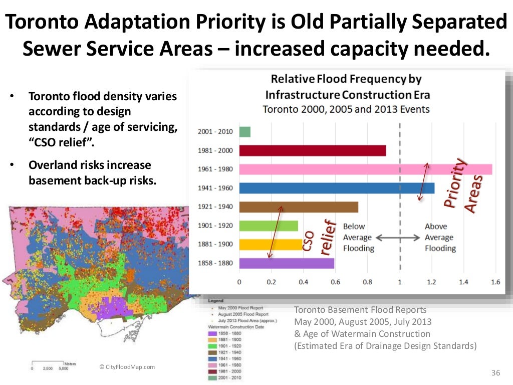
And reviews of flood density in Toronto based on era of construction (I used watermain installation date as a surrogate) (see slide 36):


• Toronto flood density varies
according to design
standards / age of servicing,
“CSO relief”.
• Overland risks increase
b...

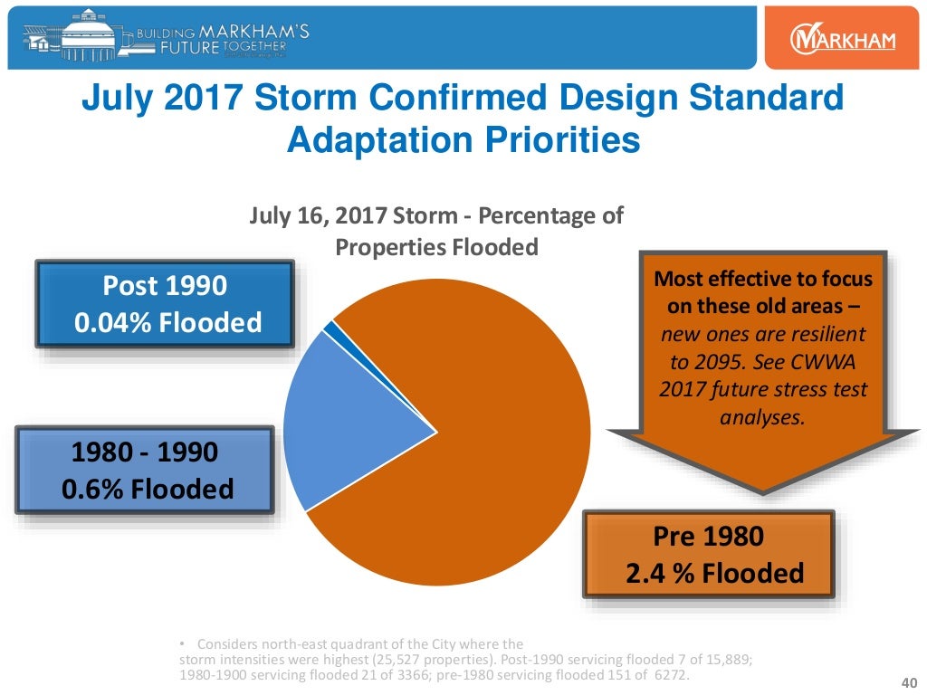
Or in Markham (see slides 39 and 40) in the above link (I used storm sewer installation date).

July 16, 2017 Storm - Percentage of
Properties Flooded
July 2017 Storm Confirmed Design Standard
Adaptation Priorities
Pre...

So what can we expect when we look at the flood risk profile across Canadian cities based on these Servicing Eras? First, we can expect to see a vast variation from city to city based on its growth and servicing history. Using Statistics Canada data on from the 2016 census for Ontario, we can use the date of housing construction as a surrogate for the date of municipal servicing - this approach has limitations because housing may be in place before servicing in isolated cases (i.e., servicing is newer than the housing), and servicing may be upgraded over time (i.e., capacity upgrades to original servicing). The graph below looks at housing/construction eras for census metropolitan areas (CMAs) or smaller geographic units.

We see that areas with more growth (e.g., Milton, Barrie) have less than half the proportion of high and highest risk housing stock (Eras 1 and 2) compared to other low growth areas (e.g., Sudbury, Belleville). The Milton breakdown is shown on the left. Milton has over 70% Era 4 resilient housing built and serviced after 1991 (green shaded slices of the pie), whereas Sudbury has less than 20% of housing in the group. The Sudbury breakdown is also shown on the left.

Milton shows significant growth in the 2001-2005, 2006-2010 and 2011-2016 periods once water and wastewater servicing was available to this part of the Halton Region (previously well water supply limited growth). In contrast, Sudbury shows limited growth post 2006, reflecting perhaps a slowdown in the resources/mining sector following the 2008-2009 recession.


The bar chart totals were for some entire census areas encompassing several municipalities (e.g., the Toronto CMA includes may municipalities including in York Region, Peel Region and Halton Region). Within the CMA or municipalities themselves, the infrastructure construction era will also vary (see Toronto watermain installation date in the slide noted above). For example in the Toronto CMA 47 % of housing is within Era 1 and 2, while in the City of Toronto itself 64 % of housing is within those eras, reflecting older housing stock and servicing in Toronto compared to newer communities such as Mississauga, Markham, Vaughan, etc.. Toronto also has less resilient Era 4 housing stock compared to its CMA, i.e., 26 % vs 39 %, respectively. 

The type of housing must be considered where there is a high proportion of condominium / apartment dwelling types that do not have basements with the same single family dwelling back-up risks and that typically have no riparian flood risks. The City of Toronto housing units are 39% apartment, including many new condominium units, while in the broader Toronto CMA, apartments account for 29%. As a result, the resiliency of areas with a high proportion of newer apartments may be slightly overestimated.

What's next - mapping the Servicing Era and flood risk profile at a census tract level perhaps and netting out the effect of apartments and then adding in other local risk factors that are readily available.

****

And here we go with some neighbourhood variability in era of construction to show the variability in land use planning, subdivision infrastructure servicing and dwelling construction practices across several regions in Canada. The average neighbourhood age is based on Statistics Canada data at a census tract scale - sometimes that is too small a scale to assess risk and sometimes it too big, and sometimes it does not align with infrastructure system servicing boundaries. So what I'm saying is its a high level general characterization of resiliency, and one would have to drill down into specific infrastructure systems to see street by street resiliency :

Vancouver:

 Calgary:
 Golden Horseshoe / Toronto / Hamilton:
 Ottawa / Gatineau:

Montreal:


Halifax:

Other factors that characterize flood risk can also be considered, including overland flow and topographic slopes that contribute to direct surface flooding and also inflows to sanitary sewer systems (e..g, via reverse slope driveways and low opening, or windows and lower level walkouts that ultimately drain to floor drains and the sanitary/wastewater collection system).

The following images show the estimated 100-year overland flow spread for drainage areas up to 10 hectares in Toronto. Catchments with low slopes are also shown as these have been shown to influence the maximum flood density reported following extreme rainfall events.

The first map shows the Newtonbrook area of North York where the overland conveyance limitations are clearly apparent. It would appear that the topographic drainage limitations (low slopes, no overland outlet) combined with the age of construction (with partially-separated sanitary sewers) results in the high relative flood risk.


I have to say it is tempting to cherry pick the map area to prove my hypothesis is correct in terms of flood risk factors. The west end Toronto map shows the limitations in flood risk factors. For example the greatest flooding in May 2000 was not in the low slope catchments or the oldest construction area but rather in a cluster north west of Eglinton Ave West and Islington Avenue. The oldest area to the south shows one flood cluster on the overland flow path but not throughout the old area for the May 2000 event. So is construction age alone a good indicator of risk? Overall it is (analysis of all Toronto flood reports proves it is relevant), but it breaks down at the neighbourhood or sub-neighbourhood level as a predictor of risk. The best indicator of risk? Past flooding. Why? Because the complex reality of hydrologic and hydraulic systems and building construction cannot be readily simplified into list of risk factors - there is too much variability, too many exceptions and too much interaction between known and unknown factors to identify risk at a fine spatial scale.


The final map below shows another west end area where 10 hectare overland flow paths help explain some flood clusters but not others. Slope does not seen to be a driving factor where the overland drainage area is small (near Trethewey Drive), but may be a more significant factor on Jane Street where the overland flow area is more significant. What this shows is that it is combinations of factors that accentuate overall flood risk. If one factor is quite severe, it can trigger a flood cluster like east of Dufferin Street, north of Lawrence Avenue West where the age of construction is newer, slopes are good but the overland flow system behaviour alone is enough to trigger risks. Like there previous map, this one shows cluster that are off the major overland flow paths - so these do characterize risk on an aggregate basis overall, but not always at a local spatial scale.

This is perhaps the best example of overland flow risks coming to life like a 'giant tiger' during a severe storm. The picture is from Twitter at .. ummm .. the Giant Tiger store on Kipling Avenue. The store is immediately on the overland flow path - not a huge drainage area, but the building effectively blocks the flow path. The low slopes (orange polygon) around the store suggest it is in a 'bowl' (like Newtonbrook in the image above), which means the overland flow has 'nowhere to go' - good overland slopes help 'move' runoff during an extreme event. 


Looking at Mississauga, and reported flooding from July 8, 2013 one can see higher concentrations in older areas closer to Lake Ontario and in Malton (top of inset map). Newer areas that appear to have low densities of flood reports may in fact just be commercial properties with no basements and with owners or tenants who did not report flooding to the City after the storm event (e.g., areas surrounding Pearson Airport). It does appear that relatively less flooding was experienced in newer subdivisions to the west (e.g., Erin Mills).

Adding other factors such as overland flow paths to the Mississauga flooding and construction era maps shows again, like in some Toronto maps, that the combination of factors drives flood risks. Clearly higher densities of flooding within older neighbourhoods (census tracts) can be found along overland flow paths (note regulated floodplains are not shown). The tributary west of Cawthra Road between the QEW and the CNR in the Mineaola neighbourhood shows a clear line of reported flooding along the overland flow path. Other local areas in the Mineola neighbourhood do not have a high degree of reported flooding, despite the older age of building construction and servicing standards - some flooding in that neighbourhood is associated with Cooksville Creek riparian flooding risks.

Edmonton has mapped overland flooding risk areas to help educate residents on flood risks. The map below illustrates the variability in dwelling construction date across census tracts.


The following map shows areas with surcharged sewers and surface ponding risks based on the interactive map available here: http://edmontonjournal.com/news/local-news/first-defence-new-epcor-ranking-scheme-may-wake-up-neighbourhoods-to-flood-risk.

What does it show? Old areas south of the rail tracks have higher sewer surcharge risk (red pipes), corresponding to the old 'grid pattern' development. Newer areas to the north, especially north of 153 Avenue NW have very few sewer surcharge risk (i.e., fully separated sanitary sewer servicing) - those are the areas with the modern 'wiggly' road patterns. Its all coming together !


The City of Windsor experienced extensive flooding in both 2016 and 2017. The following map illustrates August 2017 flood reports.
The era of construction is shown in the map below. It would appear that oldest areas had the highest flooding reports, and newest areas (e.g., in the west) had lower flood density.


Looking back at Mississauga, we have analyzed the flood density in residential development areas by era of construction, using weighted average construction date in each census tract. The flooding locations were estimated through digitizing and therefore likely underestimate reports in the highest density areas due to overlapping symbols. Nonetheless, a strong trends appears in the data with a lower density of flooding for 1980-1989 construction compared to pre-1980 construction - this reflects the benefits of full sanitary sewer separation and more advance master drainage planning. Post-1990 construction areas show even lower flood density that 1980-1990. The ratio of flooding density in the three eras of pre-1980, 1980-1989, 1990-present was 3.1 - 1.8 - 1. Unlike the Markham densities above that are based on total dwelling counts, the Mississauga densities area are-based and therefore if modern dwelling densities are higher, the relative flooding would be even lower for more modern construction (i.e., more dwelling per area, resulting in even lower flooding per dwelling). The following map illustrate the residential areas (with the exception of Malton), colour-coded by construction era and estimated flood locations.


Looking a little closer at Mississauga and the major overland drainage system, con can see the influence on reported flooding. Older construction areas do not have uniform flood risks - while risks are higher overall, on an aggregate basis in older vs modern drainage systems, with the older areas there are distinct clusters of flooding. Often  those clusters are along a regulated valley feature or along an major overland flow path upstream of the regulated area - several examples can be seen in the map. The inset at the top right is the Malton area of Mississauga - flooding clusters are apparent along the major overland flow path beyond regulated areas - this does not necessarily mean flooding was overland, pluvial flooding, but that the major system conveyance limitations stressed the sanitary sewer system, for example, with extraneous inflows in an area that already has high infiltration flows.

***

Two key flood risk factors are combined in the following map showing the City of Waterloo. Spatial analysis of overland flow path hydrologic characteristics are intersected with city sanitary sewer system age and inferred infiltration and inflow risk to identify risk areas of interest - these can be assessed through further study, whether that be investigation of critical system conditions (e.g., CCTV inspection), monitoring of flow stresses to confirm inflow potential sewer surcharge risk magnitude,  to modelling / quantification of flood risks, or further risk characterization through investigation of past flood claims and reports. Average dwelling age of construction in census areas is labelled to show the general correlation of broad neighbourhood risk factors (i.e., construction era is a surrogate for sewer and overland drainage design standard resiliency). Individual dwellings near the overland flow path are shown in red, indicating specific local risks within new and old subdivisions.

City of Waterloo - Example Urban Flood Risk Factor Review Considering 100-Year Overland Flow Risks and Sanitary Sewer Resiliency Based on Construction Era and Inflow / Infiltration Potential (Excludes Riverine Flood Risk and Properties in Regulatory Flood Plain)
Methods for assessing urban and riverine flood risks from "Flood Plains to Floor Drains" are discussed in a previous post.