A research paper Assessment of non-stationary IDF curves under a changing climate: Case study of different climatic zones in Canada in the August 2021 Journal of Hydrology: Regional Studies by Silva et al. projected future IDF curves in several regions of Canada under various emissions scenarios (link: https://www.sciencedirect.com/science/article/pii/S2214581821000999). A previous post discussed historical annual maximum rainfall at climate stations with long-term records and noted stationary values for several stations and rainfall durations (i.e., no change in annual extreme rainfall observations) - see post: https://www.cityfloodmap.com/2021/12/has-extreme-rainfall-become-more-severe.html.
The paper presents changes in typical design intensities for:
i) 120-minute (2-hour) 5-year return period values (e.g., along with intensities for shorter durations, these data are used to design storm sewers in many jurisdictions), and
ii) 1440-minute (24-hour) 100-year return period values (e.g., used to design stormwater detention facilities, or used to derive design hyetographs for floodplain mapping in some watersheds and for RDII analysis in some wastewater collection networks prone to wet weather impacts, etc.).
Future projections are made for the period 2020-2100. The main paper presents percentage changes for the RCP8.5 emissions scenario as follows:
The charts on the above left show changes for stationary distributions, and Hamilton (HAM) and London (LON) columns are highlighted. Those stations were shown to have stationary annual maximum extreme rainfall in the paper, as shared in the previous post. The London and Hamilton 100-year rainfall intensities increase from 4 to 13 percent under the RCP 8.5 emissions scenario (stationary table on the bottom left).
Under the RCP8.5 scenario the return period of today's 100-year 24-hour becomes smaller, meaning that intensity can occur more frequently than the 1% chance per year today. Today's 5-year 2-hour intensities become more frequent as well. The paper shows these projected intensities:
So a 100-year return period 24-hour (1440 minute) intensity becomes a 73.5 year return period intensity or a 18.5 year return period intensity in Hamilton and London, Ontario, respectively.
Supplemental material shows that for other emissions scenarios intensities do not increase
at these Great Lakes climate stations for the rare 100-year intensities. See below:
For a RCP2.6 scenario, the 100-year intensities in the table (again on the bottom left for the stationary model), decrease by 3 percent or are unchanged. With those decreases the return period of today's design intensities become longer, meaning today's intensities are less frequent. That means reduced risks for extreme rainfall compared to today.
The RCP4.5 scenario projected 100-year intensities are essentially unchanged in Hamilton and up slightly in London:
So what are future rainfall intensities in Southern Ontario? That depends on the emissions scenario you select.
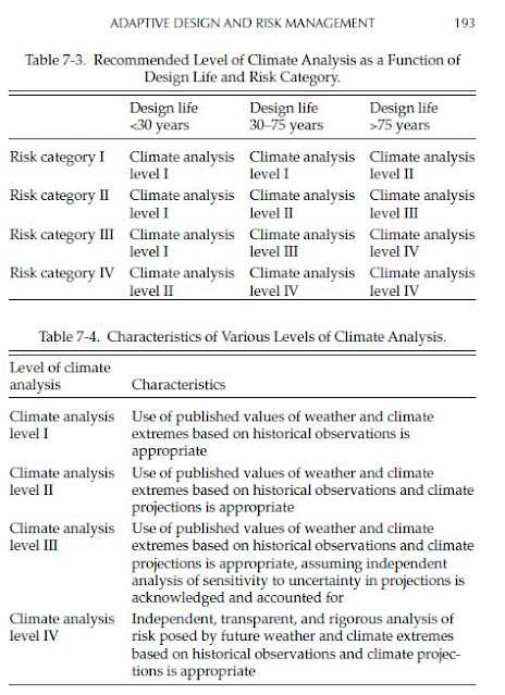
- Apply risk-based decision-making to choose the future extreme rainfall value that is most appropriate for asset risk thresholds. For example, if rainfall consequences to infrastructure are severe, consider applying upper end of projected future RCP 8.5 1-hour 1-in-100-year rainfall intensities to infrastructure design.
So for buildings and structure with design life up to 75 years, where the risk category is low (Risk Category I, meaning low risk to human life), Level I climate analysis using "extremes based on historical observations is appropriate". For a longer design life beyond 75 years, the Risk Category I buildings and structures (low risk) should also include climate projections per climate analysis Level II. In my opinion, a deterministic future projection could be considered for such analysis based on a likely scenario (e.g., RCP 4.5).


