Southern Ontario Extreme Rainfall Trends and Engineering Design Considerations for Effective Management

This blog has many posts that illustrate how the media, some researchers, and/or the insurance industry have missed the mark when it comes to defining past changes in extreme rainfall and the effects on communities. What is also apparent is that government agencies and ministries have also missed the mark when it comes to defining these changes and what it means to stormwater management policies and design standards

This post provides:

1) Examples of media, researcher and insurance industry data gaps on extreme rainfall compiled over the years;

2) A presentation made to the the Ontario Ministry of the Environment, Conservation and Parks with information for Ontario (MECP) showing inaccurate government statements on past trends, and actual data characterizing southern Ontario trends to help guide development of standards for stormwater systems; and

3) References to updated material that expand on and confirm the above.

***

1) Examples of the media, researchers, and the insurance industry misstating extreme weather and rainfall trends

CBC and Radio-Canada - this blog post compiles corrections by CBC and Radio-Canada related to extreme rainfall frequency since 2015, including corrections to or the deletion of articles that violated their journalistic standards and practices, including the commitment for accuracy in reporting: https://www.cityfloodmap.com/2019/06/cbc-correcting-claims-on-extreme.html

Key take-away: even large media organizations are not well-equipped to critically report on the basics of extreme rainfall. 

TVO - this blog post includes a critique of storm intensity and extreme temperature reporting in 2017 and 2019: https://www.cityfloodmap.com/2017/11/tvo-articles-on-climate-change-extreme.html

Key take-away: smaller media organizations are not well-equipped to critically report on the basics of extreme rainfall or temperature trends either. 

Insurance Industry / Researchers (plus more media) - this presentation shows that many cannot tell the difference between a theoretical, arbitrary 'bell-curve' shift in extreme weather frequency and actual observations, and that there is no fact-checking in most media. This relates to the widely-reported incorrect claim in the Institute for Catastrophic Loss Reduction (ICLR) report "Telling the Weather Story" for the Insurance Bureau of Canada (IBC) that "weather events that used to happen once every 40 years are now happening once every size years": https://www.slideshare.net/RobertMuir3/storm-intensity-not-increasing-factual-review-of-engineering-datasets

Key take-away: media organizations, and even the chief economist at a large Canadian bank, do not verify suggested extreme rainfall or weather trends in Canada, and will widely echo unsupported/incorrect/false statements. In this case the insurance industry had not checked the researcher statements in a report they commissioned.

2) MECP presentation on extreme rainfall trends to guide stormwater design standards

The MECP embanked on the development of design standards for wastewater and stormwater systems in Ontario to support Consolidated Linear Infrastructure (CLI) Environmental Compliance Approvals (ECAs). CLI ECA's for stormwater systems (like wastewater systems) are intended to consolidate individual ECA's for stormwater infrastructure in a municipality.

Adapting to a changing climate is one consideration in developing stormwater management standards and criteria. New, expanded criteria have been proposed for stormwater CLI ECAs, largely echoing the MECP's draft Low Impact Development Stormwater Management Guidance Manual criteria such as managing 90th percentile storm events (see January 2022 ERO posting: https://ero.ontario.ca/notice/019-4971). The ERO posting notes several goals including:

"The draft Low Impact Development Stormwater Management Guidance Manual aims to ... Increase resiliency of communities and associated stormwater infrastructure to climate change and help mitigate climate change"

A presentation was made to the MECP Stormwater Design and Permissions Working Group on May 1, 2019 to support the stormwater CLI ECA development, providing actual data on past trends. Some highlights are below illustrating that:

i) the former Environmental Commissioner of Ontario also echoed the above incorrect/unsupported insurance industry statements on increasing extreme weather frequency:


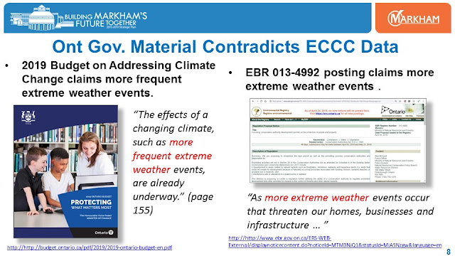
ii) Ontario government documents claims more frequent extreme weather is 'already underway':


iii) The LID Manual, including the November 2017 draft cited below (link: https://drive.google.com/open?id=1NHtrjCglDgox4tYISLU5LLZYS32Ea4MN)
and the January 2022 noted above, cites only the increases in maximum rainfall intensity in Ontario, omitting significant negative trends in southern Ontario that demonstrate decreasing risks


The 2022 draft LID Manual includes the same highlighted 'red box' text above in Table 6.1 – Examples of Observed Changes in Ontario Climate, namely:

"The maximum intensity for 1-day, 60-minute and 30-minute duration rainfall events increased on average by 3%-5% per decade from 1970 to 1998 (Adamowski et al., 2003)."

The citation is as follows: Adamowski, K., J. Bougadis, and G. Pessy., Influence of trend on short duration design storms, pp. 15. Department of Civil Engineering, University of Ottawa, 2003.

To provide a more complete perspective on rainfall intensity trends, Kaz Adamowski and John Bougadis also analyzed trends in Ontario rainfall intensities in 2003 in HYDROLOGICAL PROCESSES (Hydrol. Process. 17, 3547–3560 (2003)), published online in Wiley InterScience (www.interscience.wiley.com), DOI: 10.1002/hyp.1353. As shown below, that analysis found both increasing and decreasing trends - not just the increases cited by MECP.

Adamowski and Bougadis found significant increasing trends only in northern Ontario. In southern Ontario 'significant negative trends' were observed for all durations, except the 2 hour. Central Ontario had positive trends, but none were statistically significant:

The full slide presentation to MECP including the selected slides above is as follows:


Clearly the Ontario government and MECP has not adequately characterized extreme rainfall trends in the province, and presents only partial, dated analysis that is inadequate to define and support new stormwater management standards or policies considering actual risks.

3) References to updated material that expands on and confirm the above

Historical extreme rainfall trends in Canada and across Ontario have been summarized in the National Research Council of Canada (NRC) National Guidelines on Undertaking a Comprehensive Analysis of Benefits, Costs and Uncertainties of Storm Drainage and Flood Control Infrastructure in a Changing Climate (see post: https://www.cityfloodmap.com/2022/02/nrc-national-guidelines-on-flood.html).

The Ontario trends noted in the 2019 slides above, that included IDF data Environment and Climate Change Canada's Version 3.00 Engineering Climate Datasets, have been updated with Version 3.10 data. For example, southern Ontario annual maximum trends and IDF trends based on recent updates are shown below:


In this heavily populated region, where there is a vast amount of infrastructure, clearly there are many decreasing trends in observed annual maximum rainfall at the long term climate stations. This contradicts the statements by the media, some researchers, the insurance industry and the Ontario government.

The following figure shows IDF trends since 1990 for long term climate stations. On average small 2 year rain intensities are lower and extreme intensities are unchanged.


Therefore data continue to not show any 40 to 6 year frequency shift in extreme rainfall across Canada, as claimed by some researchers. Overall, extreme rainfall intensities have decreased at over 200 climate stations with available data in Canada as illustrated in the NRC guideline (see the blog post noted above for details). In southern Ontario, some intensities have decreased on average, like the 2-year rainfall intensities, consistent with Adamowski and Bourgadis' 2003 analysis noted earlier.

Stormwater management standards in Ontario, whether in a LID Manual or CLI ECA criteria, should consider the actual rainfall data trends and the resulting risks to systems. This is currently not occurring. 

Consistent with past observations of extreme rainfall trends are the future projections for southern Ontario (see post: https://www.cityfloodmap.com/2022/01/future-extreme-rainfall-idf-values-in.html). In Assessment of non-stationary IDF curves under a changing climate: Case study of different climatic zones in Canada in the August 2021 Journal of Hydrology: Regional Studies, Silva et al. projected future IDF curves in several regions of Canada under various emissions. When more plausible emissions scenarios are considered (see RCP2.6 projections below), the 100-year intensities decrease in London and Hamilton:


For RCP4.5, Hamilton has projected increases and decreases in 100-year intensities depending on the duration, and London has minor increases (no more than 5%) - increases of such small magnitudes in one input parameter are not relevant in engineering design given the dominance of other factors related to the transformation and application of the data in hydrologic analyses (e.g., hyetograph selection).

Other research by the University of McMaster entitled Assessment of Future Changes in Intensity-Duration-Frequency Curves for Southern Ontario using North American (NA)-CORDEX Models with Nonstationary Methods predicts that extreme 50-year rainfall amounts will decrease in Southern Ontario by 2050, that moderate 25-year rainfall amounts will remain flat, and frequent 10-year rainfall amounts will increase overall for long durations, but are mixed for short durations. See previous post: https://www.cityfloodmap.com/2018/04/climate-models-predict-decreasing.html. The following tables illustrate projected 50 year return period trends from that study, with decreasing trends shown in blue:


The projected change in extreme rainfall for the majority of durations and locations in southern Ontario is negative, i.e., decreasing rainfall design intensities.

Stormwater design policies and standards in Ontario should consider future climate effects and future, long term risks. In southern Ontario, where most stormwater infrastructure exists, it is not clear that projected rainfall intensities used in design will be increasing significantly, if at all, based on several sources above. Accordingly, a robust risk-based approach to setting standards or policies for adaptation is needed that weighs the cost of any new standards against their benefits, especially in regions with past decreasing trends and limited projected increases - those regions include southern Ontario. Where benefits are low due to limited expected rainfall changes, and adaptation costs are extremely high (see this presentation to MECP on costs of LID measures for example: https://www.slideshare.net/RobertMuir3/cost-effectiveness-of-lid-implementation) such a robust risk-based approach is even more essential to ensure that investments in any higher infrastructure standards are worthwhile. Such an approach has not yet occurred in the development of Ontario's draft LID Manual or CLI ECA criteria, when it comes to managing stormwater and extreme rainfall.

Based on the above, Ontario's draft LID Manual should be critically reviewed, expanded and updated with respect to actual extreme rainfall trends and projections in Ontario. The need for increased resiliency (and the associated cost of generic one-size-fits-all measures), when actual observed and projected risks are low, should be reconsidered

Green Infrastructure - Capital Costs to Implement Low Impact Development Stormwater BMPs

The National Research Council of Canada (NRC) has released the National Guidelines on Undertaking a Comprehensive Analysis of Benefits, Costs and Uncertainties of Storm Drainage and Flood Control Infrastructure in a Changing Climate.

The full guidelines are available here to download: https://nrc-publications.canada.ca/eng/view/object/?id=27058e87-e928-4151-8946-b9e08b44d8f7

The guidelines delve into many topics to support comprehensive benefit cost analysis. Previous posts explored these topics:

1) Historical extreme rainfall trends related to flood damages (see post: https://www.cityfloodmap.com/2022/02/nrc-national-guidelines-on-flood.html).

2) Insurance industry loss data to assess of direct and indirect flood losses, i.e., the potential benefits of new/upgraded flood control infrastructure (see https://www.cityfloodmap.com/2022/02/nrc-national-guidelines-on-flood_27.html)

The guidelines also present costs for a range of flood control and drainage measures in Appendix F, Life Cycle Costs of Storm Drainage Infrastructure, Annex F1 including for measures such as:

  • Regional Storage
    • Dams 
  • End of Pipe Storage
    • Dry Ponds
    • Wet Ponds
    • Engineered Wetlands
    • Infiltration Basins
  • Local Storage/Management
    • Underground Storage
    • At-Source Solutions
    • Enhanced Grass Swales
    • Infiltration Trenches
  • Conveyance and Conveyance Controls
    • Storm Sewers
    • Channel Improvements
    • Bridges
    • Culverts
    • Pump Stations 
  • Area Protection
    • Berms/Dykes
  • Building Protection
    • Backwater Valves & Downspout Disconnection
This post shares some cost data to support the planning-level estimation of green infrastructure costs, i.e., local storage/management involving at-source control measures. Some comparisons with the unit costs of other measures referenced in the NRC guidelines is provided as well.

Alternative terminology for engineered measures with at-source storage were noted to include:

Green infrastructure enhanced assets & engineered assets – Defining Municipal Natural Assets (Municipal Natural Assets Initiative, 2017)

Green stormwater infrastructure – Green City Clean Waters, The City of Philadelphia’s Program for Combined Sewer Overflow Control (Philadelphia Water Department, 2011)

Lot level and conveyance controls – Stormwater Management Planning and Design Manual (Ontario MOE, 2003)

Stormwater best management practice – Best Management Practices Guide For Stormwater, Prepared for Greater Vancouver Sewerage and Drainage District (Vol 1a and 1b) (Dayton & Knight Ltd. et al., 1999)

The follow charts and tables present capital and operating costs for many at-source stormwater control measures as presented in the NRC guidelines. Capital costs are shown as a function of storage volume provided or drainage area served - that is to support a 'top down' assessment of costs that can be used in planning studies and strategy development, in advance of any preliminary or detailed design and implementation. These costs were developed based on extensive data was analyzed from the City of Philadelphia's Green City, Clean Waters Pilot Program - that program includes comprehensive planning, implementation and assessment of green infrastructure for CSO control, using a consistent design volume target. The costs are based on actual costs of implemented projects within the program, that have undergone preliminary design, screening for affordability/adaptation, detailed design and construction.

Note that because the Philadelphia program achieves as consistent design volume, costs by area served are also related to design volumes achieved. Other projects analyzed included those within the U.S. EPA BMP Database (where costs and design volumes were available), and projects implemented in the province of Ontario and also Alberta. Those projects did not have consistent design volumes (i.e., targets) and on average implemented smaller control volumes based on available data.

The following chart from the NRC guidelines present capital costs for construction of green infrastructure in the Philadelphia program as a function of design volume provided. The costs, expressed in 2018 USD for the projects analyzed averaged $56.4 / cubic foot, or $2000 / cubic metre of storage provided, aggregating across all BMP types.

As an aside and for comparison, the cost for large-scale centralized dam/reservoir storage was identified as follows in the guidelines (based on Petheram & McMahon, 2019):

        Cost = 13138 x^-0.555

Where “Cost” is the cost of a mega-liter (ML) of storage capacity (presented in 2016 Australian dollars) and x is the storage volume in gigalitres (GL). So for a 10 ML reservoir, equivalent to 10,000 cubic metres, the cost would be $3660 or $0.36 per cubic metre, which is several orders of magnitude less than the average cost of at-source storage ($2000 per cubic metres). This is simply to illustrate the economies of scale of larger, centralized controls such as regional reservoirs in comparison with small, at-source green infrastructure controls.

To compare with smaller, local end-of-pipe storage measures such as wet ponds, the following costs were identified (based on a Greater Vancouver Sewerage and Drainage District study Best Management Practices Guide For Stormwater (Dayton & Knight Ltd. et al., 1999)):

        Cost = $28.90 × (35.31 × V)^0.70, where V = cu.m of storage volume  

The study noted that typical wet pond construction costs range from $26 – $53 per cu.m of storage volume - unit costs would be higher in 2018 dollars, e.g., $50 – $100 per cu.m of storage, scaled using Statistics Canada's building construction price index for the Toronto area. Of note is that the unit costs for end-of-pipe controls are an order of magnitude less than the smaller cost of at-source controls, again showing the economies of scale associated with larger, more-centralized works.

The next chart shows green infrastructure capital costs in the Philadelphia program as a function of total drainage area served, or controlled. Note that the Philadelphia projects provided an average of 38.9 mm of storage across drainage area served. The average cost was $346,000 per acre or $856,000 per hectare, expressed in 2018 USD. 

As another aside, in comparison with end-of-pipe storage such as wet ponds, the NRC guidelines present the following table with wet pond construction costs (2020 CDN $):


The capital cost per hectare served for wet ponds is an order of magnitude lower than the cost of at-source controls when expressed as a cost per hectare (i.e., $25,000 to $52,000 per hectare for wet ponds and over $800,000 per hectare for green infrastructure measures).

The following chart breaks down green infrastructure capital cost by low impact development (LID) BMP type, including infiltration trenches, pervious pavement, rain gardens and tree trenches. Note that some projects includes multiple BMP measures and therefore the classification can represent the core measure implemented when multiple types were combined. The costs per volume show higher costs per permeable pavement than other LID BMP types. 

The next chart shows the variation in costs as a function of drainage area served.

Below the overall costs are in the Philadelphia Clean Waters Pilot are compared to costs for projects in the USEPA International BMP Database, and projects implemented in Ontario and Alberta, Canada. The Philadelphia program costs represented the largest area controlled and the largest design volume provided.

The USEPA BMP Database cost per drainage area was a fraction of Philadelphia project costs, however, the average volume provided was significantly lower as shown above. In the case of the Ontario and Alberta projects, limited data on design volume was available but it is expected that targeted volumes would be between the Philadelphia and USEPA BMP Database volumes, based on common practice to target small storm events in many jurisdictions to manage water balance, water quality control and erosion stress reduction benefits.

Operating costs can represent a significant proportion of the present value of flood control and drainage infrastructure, and these costs vary by infrastructure type. The following chart from the guidelines illustrates how the present value of infrastructure, including both capital and operating cost, varies according to the operation and maintenance (O&M) requirements and the service life of the infrastructure.


The Best Management Practices Guide For Stormwater (1999), Prepared for Greater Vancouver Sewerage and Drainage District provides the following percentages for various at-source storage (and other end of pipe storage) measures:

• Dry Detention Basins: budget 1% of construction cost per year

• Wet Pond: budget 3% to 6% of construction cost per year

• Roof Downspout Systems: budget 3% to 6% of construction cost per year

• Infiltration Basin: budget 1% to 3% of construction cost per year

• Bioretention And Dry Swale With Underdrains: budget 5% to 7% of construction cost per year (assumed the same as grassed channels and wet swales)

• Sand Filters: budget 11% to 13% of construction cost per year

When operating costs are over 5% of capital cost, for example for bioretention measures, and where the service life is 25 years, the chart above indicates that the present value of O&M costs are over twice the value of the capital cost. This point emphasizes the importance of considering O&M costs when evaluating varied flood control alternatives.

These percentages representing annual O&M/capital cost can be contrasted to the operating costs for other measures regional storage and conveyance measures. The guidelines report lower percentages for dams/regional storage. An Australian study noted operation and maintenance costs that range from 0.08% to 0.86% of final (capital) costs, with a median value of 0.21%. As a specific example, for the Springbank Off-Steam Flood Storage Site the operation and maintenance costs were noted to be in the order of 0.3% of construction (including engineering) costs. While there is limited information available for rehabilitation costs for the Springbank Off-Steam Flood Storage Site, rehabilitation (capital) costs were determined to be in the order of 3.7% of initial construction (including engineering) costs, incurred every 10 years, adding 0.37% per year. From this, it appears that operation and maintenance and rehabilitation costs for larger scale works, such as dams/reservoirs is less that that of smaller local storage or at-source controls.

In absolute costs, annual O&M costs for various green infrastructure measures were summarized as follows for the Philadelphia program, expressed as a function of impervious surface controlled:

With a capital cost of $320,000 per acre (2018 USD) identified in the chart above, and assuming 50% impervious, the capital cost per impervious acre would be in the order of $640,000 per acre. The tabulated O&M costs are equivalent to less than 1% of those capital costs. As the O&M costs in the table above are in 2008 USD, the percentage assessed in 2018 USD would be expected to be higher. 

The table below presented in the guidelines presents capital and operating costs for various green infrastructure types in the Philadelphia program and suggests an average percentage of O&M cost/capital cost of 2.3%.

Lastly, the guidelines present cost estimates for different implementation scenarios including retrofits and redevelopment. As shown in the table below, the cost for retrofits can be significantly higher that the cost for redevelopment.